Valley of Fire State Park Excursion

ValleyOfFire CS 073

The first thing you need to know about camping at Valley of Fire State Park during the Thanksgiving holiday is that it is busy.  The campsites in the park fill up quickly.  We arrived on Wednesday around 10:00 am.  The park staff at the west entrance gate told us that there were only a few primitive camping spots left at the Arch Rock campground.  However, we boldly decided to take a chance and drive through the Atlatl campground where there were some sites with electrical and water hookups.  To our surprise, we found an open campsite with hookups.  The campsite had a pretty significant grade; regardless, it became our home for the weekend.

Our goal for the weekend was to capture some pictures for our photographic portfolio.  We had a loose plan to capture some landscapes photos in the morning and at sunset and maybe try for some moon, light painting and star photos after dark.

We were traveling with our elderly dog Prince, so our photography had to accommodate his schedule.  There was a time when Prince would have been up for long hikes into the desert and been happy to have been up from sunrise to sunset.  Now, at 14 years old, he finds our hiking schedule too aggressive.  So, getting up early in the morning for a dog walk before we head out with cameras makes it difficult to plan any photo sessions at dawn.  After Prince’s walk, we can leave him in our RV for his morning nap and we set off for our planned hikes.  We returned each day at noon and spent time with Prince for another dog walk and sitting out outside at our campsite.  Then after dinner, we could get out for another photography session.

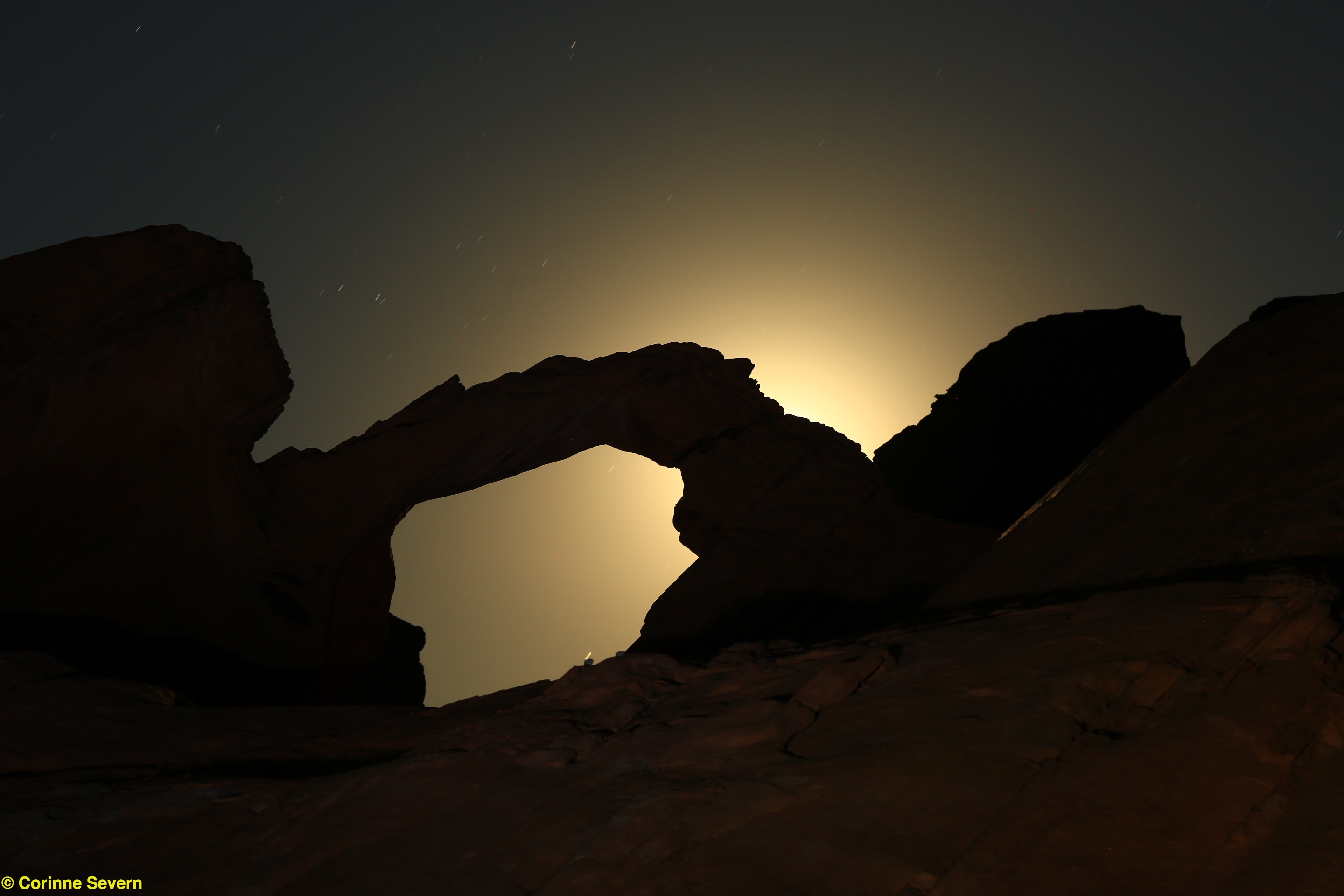
On our first evening at Valley of Fire, we went a short distance from our campsite to Arch Rock.  We had done a little research and reviewed the location in the early afternoon.  The full moon was going to rise shortly after dark on an angle that might allow us to shoot it using the Arch as a frame.   Although we had nailed the planning, our equipment was not quite up to the task of getting the photo we wanted.   The moon was full and bright, but our flashlights were not sufficient for lighting up the foreground of The Arch.  We did capture a couple of nice pictures with the moon backlighting The Arch.  After of couple of hours of working the scene, we were both cold and it was time to retreat to the trailer for a hot drink.

ValleyOfFire CS 046

On Thanksgiving morning, we hiked the Prospect Trail.  This is a wonderful trail that can be followed to a junction with the White Dome Trail.  We planned a shorter 2 mile walk up into the pass where there are a series of interesting rock formations.  We had planned to spend about an hour among the rocks, but in the end we spent the entire morning working around the rocks.  The light was pretty good for mid-morning and finding great compositions was challenging and fun.

Friday morning we had planned to do two hikes, one on the Duck Rock Trail and one on the White Dome Trail to shoot the slot canyon once the sun was a little higher in the sky.   It was a short hike out to Duck Rock.  Unfortunately, at the time we arrived, the angle of the sun and thick cloud layer made shooting very difficult.  We tried to capture a decent image from a bunch of different angles. We walked to the far side of Duck Rock (it doesn’t look like a duck from that side) and we even hiked up an adjacent hill but nothing we did resulted in a composition that we liked.

Before we returned back to the car, Corinne suggested we continue down the wash to see if there might be something of interest a little further along the trail.  We scored!  Being open to walking a little farther can be the biggest factor in finding wonderful landscape subjects.  Less than a quarter mile down the trail, we ran into a series of natural tanks.  These are depressions that hold water.  Tanks are rare and important to the desert habit.  They provide water for local wildlife.  From the rock ledges above the tanks, the entire valley opened up providing a very interesting vista. 

ValleyOfFire SS 091

The geology in the area is very colorful.  We spent hours moving around the rocks, trying different compositions.  We spent so much time at Duck Rock Trail that we never made it over to White Dome Trail.  It was getting on to early afternoon and it was time to return and spend time with Prince.

Friday night found us out doing some light painting of the rocks near the campground.  Shawn gets a kick out of creating unexpected scenes on the rocks.  Corinne was more interested in getting a photo of star trails.  Unfortunately, right after we decided to switch from light painting to star photos, a cold wind started to blow.  Even with heavy cameras and excellent tripods the camera shake was very obvious.  Furthermore, the temperature dropped from being merely cold to uncomfortable!  It was time to retreat to the RV for a hot drink.

ValleyOfFire SS 132

On Saturday, we returned home to Las Vegas.  It was a short but fun trip.  Now it is time to see if we can make the most of the photographs we captured.

Ely to Las Vegas

Prince got us up twice during the night for trips outside. We slept in until 8:00 am or so. Once we were up, showered and dressed, we took Prince for a longer hike on the BLM land behind the campground. The temperature was still brisk, but there was no wind this morning. There was snow on the ground and the temperatures were close to freezing. However, we were hiking under a bright blue sky. We enjoyed the opportunity to have a good long walk and to let Prince off the leash again. Prince found lots to explore and had the chance to chase a couple of ground squirrels.

When we were back to the RV, Corinne made some pumpkin spice pancakes with pecans. It was nice to have a hot sit-down breakfast rather than our usual breakfast bars.

After breakfast, we did a number of chores. Corinne vacuumed the carpets. Shawn packed up some of the clothes into travel bags to prepare for transfer from the RV to the house. Shawn got the Jeep hooked up, emptied the holding tank, and checked all the engine and heating system fluids. Although this resulted in a later start on the road, it meant that we had some of tidy up completed in the pleasant setting of the campground rather than a storage yard.

The weather was much more pleasant today. The sun was shining and the winds were much lighter. The trip was quite easy until we got back to Las Vegas. There a construction project on I-15 in the center of Las Vegas. They had traffic limited to one lane. Essentially, that meant that there was a traffic jam for about 10 miles. We decided to go around the perimeter of the city which added some distance, but probably saved some time.

Unpacking went smoothly, although a security person came to tell us that we weren’t allowed to have our RV in front of the house while we unpacked. We made appropriate apologies and said we would finish shortly. In fact, we were completely unpacked in about an hour. Then we took the RV to the storage faculty without difficulty an picked up some “naked” (no sauce) ribs from Dave Famous BBQ for dinner. Trip completed!

Mountain Home to Ely

Prince had a very bad night. He was sick and had the runs. Corinne ended up spending most of the night getting up to walk him. He was clearly uncomfortable and just couldn’t settle down. So we didn’t sleep well and we were a little less energetic this morning.

It was cold this morning. We walked Prince around various areas within the campground and up and back the driveway. Corinne made Prince some rice for breakfast, which seemed to settle his stomach. After his rice, he seemed a little happier. Thankfully, he was fine most of the day and settled down on the RV, dosing and sleeping most of the day.

We didn’t waste too much time before we were out on the road again. Since we had stayed in Mountain Home, we were able to drive through Twin Falls after the morning rush hour. It got quite windy during the drive and we had some rain showers. We stopped at the Love’s truck stop in Wells, NV for our lunch break. Adjacent to the truck stop, there is a big empty field where Prince could enjoy a short off-leash walk. We had a bowl of chicken noodle soup for our lunch and then bought a couple of sweetened/flavored coffees to enjoy during our afternoon drive.

The mountains along the highway had snow on the tops and low clouds. It appeared that snow was still falling at the higher elevations. Shawn had to work harder to drive with the crosswinds. Today was really the first day that the wind was a factor in the driving. Our Country Coach Affinity is pretty heavy and it takes a fair bit of wind before it becomes a challenge to drive. However, it is particularly susceptible to gusty conditions on the side of the coach. Shawn is getting pretty good at identifying the spots where a wind gusts are likely to push us around. However, every once and a while, he will get surprised. Driving in these conditions is the most tiring for Shawn. He needs to be paying attention all the time and be ready to react quickly.

We stopped at the KOA campground in Ely NV for the night. This is a frequent stopping place for us. There are good trails which allow us to enjoy some easy hikes right at the park. The campsites are a little shorter than some of the newer parks, but the lanes are very wide so they allow a little hang-over of the motorhomes with tow vehicles. We unhitched our Jeep after Prince had a short walk and we went to the grocery store in Ely to get a few items that Corinne wanted to use for dinner.

We got back from our short trip into town and Corinne cooked some Southwestern Turkey Meatballs which were very good. A huge benefit of traveling by RV is the opportunity to prepare all our own meals. Planning meals takes a little more thought than at home or on the boat since there is a microwave /convection oven that is not very good. So more of the meals need to be made on the stoptop.

We put on a DVD movie for the evening while we sipped a cup of tea. It was nice to be warm and cozy inside.

Through Oregon and into Idaho

Mountain Home RV Park (from Mountain Home RV Park web site)

We were up at O’dark thirty (6:00am) today. Shawn seemed ready to get up and Corinne wasn’t likely to fall back to sleep. Shawn was actually surprised how alert he felt. Sometimes the driving, especially in bad weather can really tire him out. However, we didn’t try to push the distance too much yesterday and we did stop early enough to get some exercise. We had a quick shower this morning and then left with Prince for a walk. Our first stop was the local Starbucks and then we strolled the large block around the neighborhood and back to the RV park. We completed our morning chores and hooked the Jeep back on the RV. By 8:00 am, we were rolling out to the highway. Due to the dead battery problem we had on our northerly trip, we were being a lot more careful to turn the Jeep off at night and take it for some short trips some evenings. It’s nice to having the Jeep along. It gives us a chance to see a like more. We just park the RV in a safe location and take the Jeep. I think Corinne likes the fact we can pick up groceries and anything that we need without having to maneuver the RV in and out of parking areas. We also tend to take Prince further a-field for walks and hikes. We have become quite adapt at connecting and disconnecting the Jeep. We use a Falcon All-Terrain tow bar system.

It was quite gloomy and started raining shortly after we began today’s trip. When we started up the slope into Pendleton, Oregon, it got foggy too. However, the road was almost empty. We like to take the “back way” to Las Vegas. The trip is a bit longer, but the driving is so much easier. We actually enjoy most of the trip, particularly once we change from I-90 east to I-82 south in Ellensberg, WA. The rest of the trip to Las Vegas is very easy, with little traffic and fairly interesting scenery.

We stopped at a rest stop north of Baker City for our lunch break. We had chicken salad sandwiches with dried cranberries, apples, and walnuts from some chicken leftovers. It was a nice lunch. Being able to have lunch on the RV really makes it a lot easier for Shawn to maintain my weight. The avoidance of fast-food and diners keeps his blood-sugar on track as well. Having our own bed to sleep in and regulated meals really helps us feel fresh and relaxed during the trip.

After our lunch break, Prince had a short walk around the rest area. It was cold and windy and not a very interesting spot to walk. So we didn’t spend much time outside before we hustled Prince back to the RV.

By 1:00 pm, we were traveling southeast again. South of Baker City, near Rye Valley, we saw a nicer rest area; possibly a place we could use on another trip. As we continued southeast, it began to rain. It was fairly unpleasant, but not a downpour. Again, it was cold and the road was pretty slippery. Fortunately there was no wind and the traffic was very light.

We continued to Mountain Home, ID where we decided to stay at the Mountain Home RV Park for the night. This was about 40 minutes west of Glenns Ferry, where we often stay at the Carmela RV Park. It seemed better to stop here since we had lost an hour due to the time zone change. The last time we tried a park in Mountain Home, it was in a less than attractive neighborhood. This park was easy to get to from the highway and had nice concrete RV pads. The lanes accessing the sites were sufficiently wide for Shawn to easily navigate with the Jeep still attached. There was a beautiful rose garden in the center of the entrance driveway. Each camp site had a nice grassy spot and picnic tables. There were lots of pull-through sites which were quite long. There is a city park in Mountain Home which appears to be within walking distance, but it was too cold and rainy to get us interested in a long walk. If you arrived late, there were nice RV spots which are left vacant close to the office. The night spots are marked with blue lights. Next to the RV park, there was a Chinese food restaurant which the park staff said was good. The park staff were also very nice. This was the first time one of the park staff at any park we have stayed at offered to connect the RV to the power and water.

When we got parked, we took Prince out for a very short walk in the rain. There was a large empty field at the end of the RV park where we walked. Once we got back to the RV, we heated up some chili for our dinner. During the evening, Corinne used the wi-fi coupon from the RV park staff to do some work on our blog and check for RV parks for tomorrow. There was a good Internet signal.

Leaving Anacortes for home

Today was the start of our southbound trip from Anacortes to Las Vegas. We didn’t want to deal with rush hour traffic through Everett, Kirkland and Bellevue, so we didn’t start our travels until 9:00 am. It was cloudy this morning and as we got to I-5, it started to rain. It rained most of the morning, but lightened up after we got east of North Bend. Not only was it wet, but it was also cold. The roads were slippery, mostly from the rain, but as we got up in elevation, the icy-feel increased.

We stopped just east of Cle Elum at a rest stop for a lunch break. It was a good stop for a break. The dog walk area had a little dirt trail which followed along a fence line and then within a small copse of trees and shrubs. Prince seemed to enjoy his exploration time. Prince was doing much better on the RV than he had in the past. He seemed much more settled and dosed for most of the trip.

We continued east and drove through little rain showers. Around 3:30 pm, we stopped at The Wine Country RV Park in Prosser WA. Ah! We arrived in time to disconnect the Jeep and zip down the road to the Chukar Cherry warehouse store for some tasting and shopping. We found much to enjoy there. We have such different ways of shopping. Shawn’s method is very simple; taste and then buy one of everything. Corinne has to think about each purchase. Shawn wonders if this process causes Corinne pain, since it seems she almost goes cross-eyed with thought.

Prince waited patiently for us in the Jeep, always happy to stay close to us. Then, it was his turn for some fun. We found a small city park adjacent to a little working class neighborhood. We walked around the park and then expanded the walk into the housing area nearby to stretch our legs a little more. When we looped back to the park, Prince spotted a squirrel scampering toward a large maple tree. That was good for a short chase; we have to keep the hunting skills honed. It started to rain again so we hustled back to the Jeep and returned to the RV to make some dinner. Tonight we had some leftover salmon (from yesterday’s dinner) in an egg scramble with some nice sharp soft cheese. The days are short with the fall season well underway. By 7:00 pm, it was as dark as the middle of the night. Time to put up our feet for the night.

Christmas 2010, Dec 28 – Flagstaff to Black Canyon City

The day did not start so well. In addition to heater problems, our coffee didn’t start to brew automatically as it usually does. Corinne set the coffee to come on at 7:30 PM rather than 7:30 am. I think we both thought that we were in for a difficult day!

We check the weather and determined that the temperatures were going to drop, with highs at 1 degree and snow expected. Without a working furnace, this helped us decide that we just didn’t belong in Flagstaff. It took us most of two hours pouring over our travel guides and iPad RV apps to finally decide that we should get down near Phoenix. It would get colder there, but no where near as cold as Flagstaff. The problem was that we didn’t want to be in the city. We eventually settled on trying a small town just north of Phoenix called Black Canyon City. Once we decided where we wanted to go, it did not take us long to get ourselves moving. Much to our relief, the day went fine. It was a very easy drive down (7,400 ft to 2,000 ft in elevation).

We settled in at the Bradshaw Mountain RV Resort. We couldn’t reach them by phone (it is the holidays), so we were not sure what we would find when we arrived. What we did find was that the staff had left a map of the resort with all the available spots. We took Prince for a walk and eventually settled on one that had relatively easy access and no overhanging trees. The turns are a little tight for pulling the jeep, so we unhitched it and caravanned around to our spot. Corinne helped me back in and in short order we were settled.

After a little lunch of Prime Rib leftovers that was enjoyed by all three of us, we headed off in the Jeep to explore. Corinne had researched the area on our way down and thought there was a hiking trail at the south end of the town. She was right; the Black Canyon Trail has an entrance just off the west side of the highway’s frontage road just south of the town. It was well marked and easy to find. As it turns out there are actually 2 trail entrances. The Black Canyon Trail stretches from Phoenix to Prescott with a length of about 60 miles. A second smaller nature trail called the High Desert Trail also has an entrance just to the right of the Black Canyon Trail (the nature trail is the one that does not allow horses). Not knowing any better, we struck off on the High Desert Trail. It turned out that fortune was smiling on us as this turned out to be a lovely loop trail for an afternoon walk. It meandered up to the top of a ridge and then proceeded to follow the ridge providing the walker with a number of spectacular views. It eventually worked its way down the ridge and into a cactus forest. All of the well known cacti were represented; Teddy Bear Cholla, Saguaro, Prickly Pear, and Hedge Hog. We even walked through a Cholla fruiting forest. Of course there were other desert plants present, but the cacti were very impressive. The trail took us about 45 minutes to walk but we stopped quite a bit along the way. There were a number of benches set up for people to have a sit and rest. Prince enjoyed the slower pace as he had time to hunt for “mice”.

The afternoon was so lovely that we decided to do a little exploring by car. On the west side of the Highway 17 frontage road we had noticed a series of very old buildings. The parking lot was full, which of course meant we needed to know what was so popular. We found the Rock Springs Café and Pie Company. Well we simply couldn’t go by without sampling the wares. A piece of Tennessee Bourbon Pecan and Peach Cobbler later, we were ready to explore the little market that was housed in the adjacent building. A jar of locally made “Mesa” honey was acquired and then we were on our way.

We also found the local Chamber of Commerce which had lots of information and brochures about the tourist highlights in the area. The young man volunteering at the office was very helpful and Corinne came out armed with a stack of maps and brochures. I am sure these will figure prominently in our travels tomorrow.

Christmas 2010, Dec 27 – Wahweap (Page) to Flagstaff

We were up a little later this morning. We were all a little tired from the outings yesterday. However, the smell of coffee brewing and with little coaxing from Prince it was not long before we were up and on a little walk around the RV Park/Marina. It turned out to be a pleasant morning for the walk. We started on the walk under some pretty dense clouds but it wasn’t long before the sun pushed them off.

Prince saw several bunnies, but being on the leash was not able to give adequate pursuit. It is the ultimate in torture for Prince. We walked up to and around the hotel at the resort. It is quite a large facility that is mostly closed for the winter. There were a few guests but none of the restaurants were open. We could hear someone working on the boats in the marina and the garbage truck came through, but otherwise it was pretty quiet.

Corinne made oatmeal for breakfast and we did some chores. It wasn’t long before we were ready to saddle-up and head for Flagstaff, AZ. It was a pretty uneventful trip until we got to Flagstaff. However, we ran into a little direction problem getting to the RV Park (Black Bart’s RV Park). This resulted in me taking a turn that I couldn’t make and needing to take the Jeep off its tow system while blocking traffic. The good thing is that I am pretty good at taking the Jeep off and that I stopped before I got us into real trouble. For those that are wondering why I couldn’t just back up, the towing system for the jeep does not allow for backing up. It is a great system in all other ways except when you don’t adequately plan your turn. The RV, being 40 feet long and the jeep adding another 15 ft can be pretty challenging to maneuver in a tight spot. Further complicating the maneuvering challenge is the fact that the back wheels don’t follow the front wheels. So, it is pretty easy to find yourself in a tight spot. Taking the truck driving course really helped me to judge distances and where my back wheels are going to go when I go around a corner. The other complication is that you are sitting on the front wheels. When they turn they tend to point the bus directly at the point of the turn. So you need to remember that you need to go out and around the turn and not through the turn like you would in your car. At the same time, your back wheels will tend to cut the corner. That means that large rounded turns are required. Occasionally, the way a lane will set up the turn makes this very difficult. You have to go wide to avoid the traffic but if you go too wide, you end up not being able to get around the turn. That’s what happened today. I got too wide in the turn avoiding a car and couldn’t get the front end around before I was smack up against a curb; a big miscalculation on my part. We got the Jeep off with little trouble and I was then able to back out of my predicament. Corinne then took the Jeep to find the RV Park and called me with directions when she had it located. It turns out that the GPS gives Black Bart’s location as about 0.5 miles south of its actual location.

Once we arrived and got settled, we took Prince for a walk around the park. He likes to see where he is and get his bearings as soon as we arrive. He will continue to agitate for his walk until we capitulate.

After we got Prince walked and fed, we went off to have steaks at Black Bart’s restaurant. What Corinne failed to tell me is that it was Black Bart’s Steakhouse and Musical Revue. So I was quite surprised when the serving staff ran up on the makeshift stage and started belting out tunes from famous musicals. They were good singers and very entertaining. We heard songs from Les Miserables, Show Boat, Lion King and Oklahoma. Consequently, we had a very nice evening of music and very nicely prepared steak for Corinne and Prime Rib for me. We even topped-off the evening with a serving of Apple Crumble a la mode.

After dinner, we took Prince for another short walk under a star lit sky. It was about 25 degrees. It was very cold and the water and soil had frozen. We did a relatively short loop around the park.

When we went to bed, the furnace was working fine and keeping the RV nice and warm. However, some time about 2:00 AM the furnace quit. It was in the teens outside and the RV cooled down quickly. I tried to use the overhead heaters but they won’t work below 34 degrees. So I had to break out the portable space heaters that we used on the former RV. They managed to keep the RV acceptable warm for rest of the night.


Christmas 2010, Dec 26 – Hiking on a Cool Day

Hanging Gardens

Today was another cool and cloudy day. In the morning, we took a short drive back towards Page AZ. On the east side of the Colorado River a short road takes you to the Hanging Gardens trailhead. The hike is about 0.1 miles to the gardens. The gardens are located in a sandstone grotto. The sandstone acts like a sponge soaking up water and slowly releasing it to the plants. The back wall of the gotto is thick with an ivy-like plant. I could easily imagine that the garden is quite beautiful in the spring.

After spending some time in the garden, we decided to hike down the sandstone hill towards Lake Powell. It was a healthy walk down. It appeared much closer from the Hanging Garden. It was a lovely walk. The route was along slick rock that we in short step-like terraces.

Bucktank Draw and Birthday Arch

Our second hike of the day was to an interesting spot about 10 miles north of Wahweap RV Park. Corinne had only a vague description of where cars parked and the hike began. So, she positioned us about 1,000 yards south of the wash we were supposed to walk up. We did a little hill climbing and cross-country hiking we eventually found our way to the wash, but we were about 100 ft above it on a sandy mesa. We decided to walk parallel to the wash for a little way and determine if there was an easy route down. It was clear from the path and foot falls that others had also used this route. After about 1.5 miles of walking in wet sand (my calves are going to feel this tomorrow), we found a convenient spot to drop down into the wash. We were on the far south side of the wash and decided to explore this area first. There are a number of small slot canyons (or dry waterfalls) and hoodoos that were very interesting. We spent about a half hour hiking around the area and we had a nutrition bar for our lunch. Then we decided to head back down the wash that most people use as the hiking route.

We were pretty sure that we could see Birthday Arch up on the side of a steep cliff face. So, before we went too far back to toward the main highway, we decided we would take a stab at hiking up to Birthday Arch. Hiking up in the sandy slope on the northside of the wash required some energy, but the trip was definitely worth the effort. It was a pretty spectacular spot, even on a cloudy day.

 
After taking some pictures, we started down. It was much easier heading down the slope then going up. At the bottom we ran into a German Couple who were on their way up. They were very interested in Prince. They had been following a set of dog prints up the trail. We disappointed them when we pointed out that the prints they were following were a lot larger than Prince. They wondered how come the prints only came in one direction. We explained that the dog had probably had returned by the route above the wash. We had seen his/her prints on the way to Birthday ArchI am not sure if we found Bucktank Draw or not. We found several small indentations in the wash that would fill with water. Often, these are called tanks. However, they seemed relatively small to the other tanks we have seen in the past. Some of the indentations still had water in them from the recent rains. We came upon one along the wash that had sufficient water in it that we opted to climb out of the wash. It was also starting to drizzle a little more and we know that a wash is not the best place to be when it rains. Once we hiked up, the rain stopped and the sun came out for a brief appearance. The short appearance by the sun warmed us up a little. We had some fun sliding on our boots down the sandy sides of some of the smaller washes.

We arrived back at the car in the late afternoon. This was expected to be a short 3 mile round trip, but with all the interesting things to see, it took much longer than we planned. I think we all had a great time but we were getting tired and decided to head back to the RV to warm up and prepare our dinner.

Christmas 2010, Dec 25 – Christmas Hiking

Wahweap Hoodoos

Our Christmas morning started off with a trip to the Wahweap Hoodoos. With the recent rains, getting to them is not a trivial trip. Normally, you could drive within about 1.5 miles relatively easily. A short walk down the Wahweap Wash would bring you into a stunning garden of hoodoos. Today the drive and walk were more challenging. The first indication of challenges ahead was the sign at the beginning of Cottonwood Canyon Road that said the road was closed. A second sign says the road is blocked by a rock fall at the 10 mile marker. We noticed that there were a number of tracks going around the road closure and we knew we only needed to go up Cottonwood Canyon Road a few miles to our turn-off, so we decided we would give the road a try.

You head north from Highway 89 along BLM 400. After about 1 mile you hit BLM Road 431. This is a right turn onto what can best be described as a dirt track. You take this road for about 5 miles where it splits. BLM Road 431 heads to the north (left). You follow the dirt track to the right and go about 6 miles to a dirt turn around. The recent rain had created several large deep washes. You needed a 4 wheel drive vehicle with good clearance. You would also want some experience in driving in these conditions. We needed to make several decisions to properly line up to cross the deep washes. These were dry but very steep on both sides. There are also several gates that we had to open and close as we passed through. We saw several small herds of cattle. I am sure that the rancher would be very unhappy if they were to get out.

When we reached Wahweap wash area, there was a large parking spot and an obvious hikers gate. So we parked off the road and put on our hiking packs. We walked through the gate and headed down to the wash. Corinne had entered the geo-coordinates for the Tower of Silence hoodoo in her GPS so we would be confident we were on the right track. The wash had a good sized river running. It was quite wide, often with sand and gravel islands strewn thorough-out. The water was red-brown from eroded mud and was running very fast. Along most of the water course, the wash was relatively deep; probably 4 to 6 inches. We were wearing hiking shoes, not boots, so we had to find narrow places to cross. Upstream from the hoodoos, there was a shear wall and the water ran right to the edge leaving no place to pass. By backtracking a short distance, we found a safe and dry way across. Sadly, there was no place to cross back to the side with the hoodoos when we got past the shear cliff. So we ended up taking pictures from across the wash.

The Wahweap hoodoos are quite different from the Toadstools. The Wahweap Hoodoos have solid white bases with brilliant red tops. They are arranged as if in a garden. There are large magnificent titans and small child-like ones. The spire they call the Tower of Silence is large and pure white. It does not have the red top. It sits a little off from the rest of the hoodoos. We spent about an hour walking back and forth along the river taking pictures and admiring these majestic sentinels.We headed back to the car and as we drove back along the dirt road, we noticed several very large hoodoos off in the distance. They were a fair distance away, possibly 3 miles, and were obviously very large. We found a road that veered off to the left and decided to follow it, to see if we could get close enough to this group of hoodoos to take some pictures. After about a mile we passed through a cattle gate we ended up on a large plateau. We took a few nice photographs and looked around the edges of the slopes that seemed to surround us on three sides. We saw that the road went down one of the slopes from the plateau. After a brief discussion, we decided to head down the road in the Jeep. The terrain gave Shawn several opportunities to practice 3 wheel driving. At the bottom of the hill, we were surprised to find a tiny tidy wood shack nestled in the shear white cliffs. It looked empty, but recently inhabited and well cared for. The road continued a little way further down a wash where we found a large water tank. There seemed no road past the tank, so we turned and made our way back to Cottonwood Canyon Road.
 
Eagle Sink
 
Once we got back to Highway 89, we turned west towards Kanab, UT. Corinne suggested we head to a feature on the map called Eagle Sink. We had no description of this feature, but it looked like a reasonably easy hike and had an interesting name. We got to the turn off at BLM 730 and decided to park the Jeep. It was getting cloudy and breezy and felt much colder. On the map, it looked like a 2 mile hike on dirt roads to the feature. It turned out to be a very good idea to walk because the road which headed south and sloped downward was very wet with deep, sticky mud. Our shoes were quickly covered in this gooey mud that made them twice as heavy on our feet. Corinne called them Frankenstein-shoes. After about 1 mile, the road turned west on BLM 720 and the road got drier and the walking got easier. After a short 0.5 mile walk, BLM 730 reappeared and we took it southward. We could see a large escarpment in the distance, and Shawn thought that would be when our route would take us. After about 1.0 mile the road crosses BLM 722 and then turns to the right and heads up the hill. In about 0.75 miles you come to the large escarpment. Eagle Sink is a large sink-hole just to the north of the wall. It is essentially a large round hole that drops about 100 ft straight down. We spent about 30 minutes walking around the sink and taking pictures from various sides since the sun’s angle seemed to put the hole in shadows from most directions. We didn’t see any eagles, but we did hear some birds roosting on the walls. We headed back to the car, glad we had taken the trip, but also happy to return to the warm comfort of our vehicle. In total, it was probably a 5 mile roundtrip from the Jeep to Eagle Sink.
 
 
More photos from our hikes are available at the following links:


Christmas 2010, Dec 24 – Hiking, Mud and Deep Water

Toadstools

We were up early and off to find the “Toadstools”. The parking area was a gravel lot on Highway 89 between mile markers 19 and 20. When we arrived, there were not other cars in the lot. The air was cold and crisp and it was sunny. The ground sparkled with frost as we found our way through the gate. Prince was in heaven. He tore around in circles in the pure delight of running really fast.

He settled down and we head up the wash following the foot prints made by those that had come before us. It was a fairly short and easy walk up the wash and over a small ridge. The “Toadstools” appear before you as you crest the small hill. It was beautiful.  The morning sun was still low in the east. It brought out reds and the whites of the rocks and enhanced the shadows. The sky was an intense blue which provided a wonderful background to “Toadstools”.

We stayed for about an hour, taking pictures exploring the area. We returned back down the wash towards the parking area. We ran into another couple arriving as we got back to the parking lot. We wished them a Merry Christmas.


Pahreah Town Site
 
Pahreah (pronounced pa-re-ah) is a small town site that is most famous for being the location for a series of westerns, staring actors such as Dean Martin and Frank Sinatra. There is good description of the town at the turn-off from Highway 89. There is a gravel and mud road that meanders down to the town site. The road is about 5 miles long.

We never made it to the town site. The road was still too wet to drive on. The car that went before us was sliding down the hill on slick clay mud. Corinne and I decided that it was better to head back and try on another day.

Buckskin Gulch

We next headed for Buckskin Gulch. We arrived at the turn-off from Highway 89 at BLM Road 700 and found a hand written warning at the information sign that the road had been washed out about 4 miles in from the junction. We decided to try the road. We made good progress until a spot where a wash cut the road. Corinne would not let me forge the river in the Jeep. She knew we were close to the trail head, so we parked the Jeep and found a place where we could cross the stream. We found the trailhead after a short walk, made our $20 payment to the BLM and started down the trail. The trail from Buckskin Gulch heads down along a tributary toward Paria River. The route leads to a series of slot canyons. The trail in this area is really a cow path that meanders back and forth across the stream. For approximately three quarters of a mile, we were able to find our way across the wash without soaking our feet, but eventually the stream came to a narrow point between steep rocks walls. There was no way to cross that would not result in wet feet. We decided that we really did not want wet feet so we followed the rock cliffs back to the north. We eventually found our way to the top of the rocky ledges. We took some time to admire the view, which was spectacular, and have some lunch. Prince got restless and whined until we pushed on. We found a new route back down into the canyon and headed back to the Jeep.

Page, AZ

Corinne suggested we head down the highway to Page, AZ.  I wanted to fill up with gas. I assumed that no stores would be open on Christmas Day. Page describes itself as the most remote city in the lower 48 states. The town was created by the companies that built Glen Dam. It was in remarkably good shape. It was very clean and buildings looked well maintained. It has all of the stores that we have come to expect in rural America; lots of fast food joints, and a Walmart.We wanted to take some pictures of the Glen Canyon Dam and the Colorado River as it comes out the dam. The canyon south of the dam is maybe a mile across and mile deep. There is an scenic overlook behind the Denny’s Restaurant. It has been recently renovated and provides a wonderful view of Glen Canyon Dam. Corinne snapped a number of pictures.We went further south to the lookout the Horseshoe Bend. The view area is about a 1 mile walk from the parking lot. The overlook is located on a sheer cliffside that is about a 1,000 ft above the river where it has a 270 degree turn. Corinne noted that there are no barriers or even signs telling people to stay back from the edge. We walked around the edge a little way. Corinne pointed out that from our new vantage point, it was obvious that the place where everyone stood was just an overhang…Oh my!
 
 
The sun was well to the west by the time we arrived and one side of the river was in shadow but the other side was brightly lit by the sun. Corinne took a bunch of pictures. However, I am not sure that a picture will adequately depict the scale of the cliffs and river. It was an impressive sight. Walking back to the Jeep, Corinne stopped to chat with a native American woman who was selling necklaces and earrings that she had displayed on some towels and blankets along the side of the path. Corinne bought a couple of delicate silver necklaces with polished stones and the woman expressed great gratitude that we had stopped and helped her financially. She wished us a very happy holiday.

After viewing the river, we started to head back to the RV. On the way, I found a spray carwash and got some of the sticky clay mud off the Jeep. We made another stop on a small road that allowed us to get some pictures of he dam from the southeast side of the dam. However, a small set of red rock formations provided more interest. The late afternoon sun really brought out the reds in the rocks and provided interesting shadows them to give them “personality”.

Back at the RV Park we made several stops. Corinne was hoping to get some pictures across the lake of the spires and a set of arches. The park has been thoroughly redone in the recent past. They have added several architecturally interesting shelters. After some photo stops, we headed back to the RV for dinner. While I write this Corinne is busy decorating the RV with lights and gel stickers we brought from home. The RV is looking very festive and the “Tur-duck-hen” is starting to smell really good!